Forestry with Water conservation – Series 6
Since 2013 this has become a regular phenomenon and I am afraid after one or 2 more severe catastrophe this may become a talk and start appreciating local people and complementing them that how these people have adjusted to this adverse climatic condition and may become case study depicting how to survive during such severe conditions in mountains.
Solutions which are being suggested can be classified into immediate/urgent (high cost impact) and long term sustaining (low cost impact) but slow in its effectiveness.
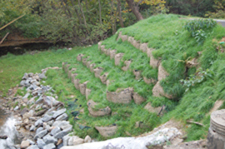
Immediate ones : To understand strategic and high impact locations, intervention at these locations will immediately control the damages and boost conservation. Timing of the interventions with locations is very important to keep the cost under control and to ensure its effectiveness. Planning to happen much before the monsoon leaving execution immediately after monsoon ie by Sept end. One structural concept is mentioned through below mentioned photograph though its costly affair but in long term its only the solution. If we wait for its greening through vegetative intervention and its stabilization it will take time and may get damaged with every severe downpour. Thus leading the impact with similar to what shown in below photograph and after its execution in its catchment low cost measure like greening with suitable grasses and planting broad leaves plants like Oaks etc and all which reduce the impact of heavy rain on the ground will reduce surface run off and as well stabilize the soil in the long run.

Simultaneously conservation of local vegetation to be encouraged first with suitable moisture conservation measures at various and strategic locations and gradients. First to be dealt at high point and later moving down gradually. Higher gradients can have permanent structure providing strength the ground surface and gradually moving down and these can simultaneously at multiple locations depending upon the fund availability.
As suggested by many experts to conduct realistic carrying capacity wrt handling of tourists annually and specially during peak days of these places which are ecologically fragile and accordingly infrastructure development to take place and that too with strict control measures and imparting desired training to the people dependent on it towards scientific and logically managing these ecological fragile zones.
Secondly possibilities of building tunnels instead of roads to be explored as tunnels provide shorter route and as well as protects the ecosystem in long run. Construction of dams or water conservations are surely needed to ensure availability of water all throughout the year for generating power and as well as for agriculture. I am not against construction of dams on hill regions rather I favor such initiatives but their size should be well balanced with the degree of sensitivity should be assessed well before finalizing the size to protect the ecosystem and fragility of the biosphere dependent on that.
Landslides have become more frequent and riskier with a beginning of more severe localized catastrophe the solution to arrest this too is only 2 ways one structural and second vegetativeto be followed as per need and suitability of the location. My recommendation to be that both means should be followed simultaneously beginning Sept end by next monsoon comes these locations to become stronger to counter heavy downpours.
The planning to be more decentralized and to be done with the involvement of locals dependent on it and who all life is at risk results will be quick and effective and long lasting.
Can’t we learn from the countries which are very ecological sensitive at one of point of time and now are the best in managing it like Brazil. None of the mountain in Brazil (wherever I have visited) is seen with even a single surface run off or land slides. Where practicing forestry is business with a meaning. Forestry is practiced commercially along with a mandate to conserve about 25% of the area with greenery and with native species. No river or rivulets is left exposed, their banks are will protected and conserved with greenery all along the banks. The scene is to be admired and practiced.

Question is finally: Can we do this for local inhabitants and for a well sustaining ecosystem ?